


ADVERTISEMENT:

A chart showing the ownership breakdown according to the valuation roll.
Valuation roll gives insight into land ownership
The latest municipal valuation roll for properties in the Makhado Municipal area gives some interesting insights, not only in terms of the value of properties, but also regarding who owns most of the land.
With the national debate on land ownership heating up, the “real figures” are often elusive and depend on who is quoting from what. The valuation roll is thus a useful starting point, as it contains information on close to 20 000 properties.
For starters, it needs to be said that the valuation roll is not a very accurate document to work from. It is not consistent in terms of units used (it jumps from square metres to hectares without warning) and it contains a large number of anomalies. (For example, ten households are indicated as having a size of only one square metre). An immense amount of “cleaning up” needed to be done just to be able to extract some information from the roll.
Census 2011 data
According to the 2011 Census data, the Makhado Municipality stretches over an area of 8 299,69 km². The population was indicated as 516 031, with 134 889 households. The figures will have changed over the past couple of years, partly because of the Municipal Demarcation Board’s decision to incorporate parts of Makhado Municipality into the newly formed Collins Chabane Municipality.
In the Makhado Municipality’s 2016/17 integrated development plan (IDP), the number of “formal residential” households is given as 9 336. The number supplied for households situated in traditional areas is 117 428. In total, 6 960 farms can be found in the municipal area.
The IDP document also gives a breakdown of ownership, stating that 49,31% of the land ownership is private. Government owns 29,91% of the land and parastatals 2,79%. The figures, however, do not add up and almost 17% of the land is seemingly not accounted for.
The valuation roll
The latest municipal valuation roll contains information on 19 211 properties, stretching over an area of 8 593,72 km². The breakdown is as follows:
|
|
Area (m2) | Number |
| Agriculture | 5,267,132,315 | 1873 |
| Commercial | 2,438,238 | 564 |
| Municipal | 312,584,403 | 7129 |
| Place of Worship / Sports Clubs | 268,358 | 73 |
| Public Service | 190,798,572 | 467 |
| State-Owned | 1,579,609,742 | 304 |
| Residential | 11,888,944 | 8801 |
| Total | 7, 364,720,572 | 19,211 |
From these figures agriculture seems to take up just over 75% of the available space. The biggest single owner of land is the government, with 18,38% listed as “state-owned”. The municipality, according to the roll, owns an incredible 7 129 properties, albeit only 3,64% of the area.
Who owns the farms?
As mentioned previously, the valuation roll is a bit of a mess and it is riddled with inaccuracies. A good possibility exists that, in cases where the ownership was not indicated, it was captured as “municipal” property. Several hundred properties exist where ownership is simply indicated as “unknown”. Uncertainty exists as to why one finds a discrepancy between the IDP’s reflection of 6 960 farms and the valuation roll’s 1 867.
Of the properties listed as “agriculture” on the valuation roll, 148 fall in the “unknown” category. Judging by the location of the sites, these are mostly government property.
Over the past two decades, a couple of hundred farms changed ownership and were handed to various communal property associations (CPAs) following successful land claims. The IDP mentions 1 042 land claims lodged with the Department of Rural Development and Land Reform. Of these claims, 898 were settled and 13 were in the process of being settled. Most of these claims (748) were claims in rural areas.
Out of the 1 867 properties listed under the agriculture section of the valuation roll, at least 355 (19%) would fall under CPA management or have black ownership. The roll does not specify race, which makes it more difficult to make an assessment based on race. The agricultural properties not identified as CPA/black-owned, or listed under “unknown”, constitute 83,45% of the total. These farms, predominantly owned by white farmers, stretch over 5 420,98 km². Compared to the total area (2011 Census figure), these farmers own roughly 65% of the land.
Size is not everything
A common complaint is that the area of the land is not necessarily a true reflection of the ownership value. The argument is made that a 1 000 Ha farm north of the Soutpansberg mountains is not nearly as valuable as a much smaller farm in the Levubu area. To get a better reflection of value, the number of properties should also be taken into consideration.
Using this as a guide, the agriculture sector only constitutes 9,75% of the total. The largest number of properties (45,8%) fall under the residential category. The single biggest land owner, based on the number of properties owned, is the municipality (37,10%).
In the agriculture section, the sector representing predominantly white farmers constitutes 73,06% of the total number of farms. Compared to all properties listed, this number drops to just over 7%.
A changing landscape
The latest valuation roll is already outdated and not a very good reflection of ownership. According to Carel Hammann, a well-known property specialist, the information used when compiling the valuation roll dates back several years. Hammann specialises in, among others, transactions involving farms. He says the landscape has changed dramatically in the past decade.
Hammann reckons that a large number of farms, especially south of the Soutpansberg, were sold to black owners or were transferred as part of the land claims process in the last couple of years. The majority of buyers are black people, with a big exodus of white residents. According to him, this is also very evident in a town such as Louis Trichardt, where the demographics have changed dramatically over the past two decades. "There are relatively few white residents left," he says.
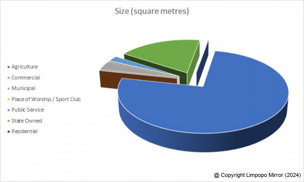
The breakdown according to the valuation roll based on the area of the properties in the various sectors.
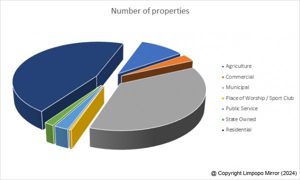
The breakdown according to the valuation roll based on the number of properties in the various sectors.
Date:07 April 2018
By: Anton van Zyl
Anton van Zyl has been with the Zoutpansberger and Limpopo Mirror since 1990. He graduated from the Rand Afrikaans University (now University of Johannesburg) and obtained a BA Communications degree. He is a founder member of the Association of Independent Publishers.
Read: 843
ADVERTISEMENT
ADVERTISEMENT:
ADVERTISEMENT:
Recent Articles
-

Phophi wa Duthuni ndi murangaphanḓa wa thimu ya Baby Protea
23 April 2024 By Kaizer Nengovhela -

Sport League Logs for 19 April 2024
22 April 2024 -

From sportscaster to advocate
21 April 2024 By Silas Nduvheni -

Magau's music prophecy gets real
21 April 2024 By Elmon Tshikhudo -

Granny Khorommbi keeps on going
21 April 2024 By Silas Nduvheni
ADVERTISEMENT
Popular Articles
-

Leopards’ top striker dreams of playing for Kaizer Chiefs
22 March 2024 By Frank Mavhungu -

Lesley Manyathela stadium remains a 'white elephant' to local clubs
23 March 2024 By Kaizer Nengovhela -

Well-known inventor, Prof Mulalo Doyoyo, dies
14 March 2024 By Victor Mukwevho -

Prophet Muritho's nightmare continues
19 April 2024 By Elmon Tshikhudo -

Masindi case likely to introduce new era of customary law
24 February 2024 By Anton van Zyl -

Park development leaves residents puzzled
22 March 2024 By Andries van Zyl -

Many questions as man shoot himself in the head
15 March 2024 By Elmon Tshikhudo